Tête du Torraz and Christomet
Tête du Torraz is a mountain in Savoie with a peak of 1930 m, well known to regular visitors to the Giettaz ski area. The hike I’m proposing here is a loop that takes in the peaks of the Tête du Torraz mountain, namely Tête du Petit Torraz, Tête de Christomet, Tête de Bonjournal and Christomet.
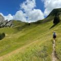
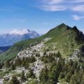
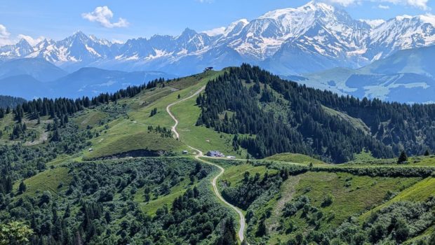
The route offers a unique view of the Aravis range as you climb the ridge leading to these peaks. The view is breathtaking, with a 360° panoramic view of the Mont-Blanc range, the Beaufortain and Aravis massifs, as well as nearby peaks such as Croisse Baulet.
- Difficulty: Intermediate

- Altitude: 1,930 m at Tête du Torraz, 1,850 m at Christomet
- Time for the itinerary: 4 hours 45
- Elevation Gain: 980 meters
- Round-trip: 14.0 km
- Map: IGN 3531 OT
Getting There
Take the D909 to La Giettaz, then continue on the D132 to the hamlet of Le Plan and park in the car park on the left just before the bridge.
GPS Coordinates (WGS 84) of the Starting Point: 45.879735, 6.524699
Route
From the car park, cross the bridge and turn right at the “Plan Duchère” sign. Continue and turn left behind the Grande Rare chairlift to follow the carriageway to the La Tréffléannaise sign, where you turn right and follow the signs for Tête du Torraz, leaving the return path opposite. Follow the track until you reach the Tête du Torraz chairlift. From here, continue for a hundred metres or so to reach the “Mouille longue” sign, where you turn off and take the narrow path that climbs steeper into the forest.
The path comes out onto a flat area and joins the track in front of a small chalet. Continue straight on, leaving the track, and take the unmarked path to the right of the chalet. Continue until you reach a place called “Varosses”. The view is now clear and you can see the Torraz ridge in the distance. The path follows the ridge and becomes steeper and steeper. It is in the last 200 metres that the effort required is greatest (but the arrival at the summit soon makes you forget it). Note the presence of an original foodtruck offering refreshments.
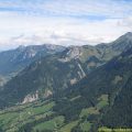
After a well-earned break, head for Bonjournal, reached after around 45 minutes of descent. Here too, a chalet restaurant welcomes walkers. The return path is on the left of the chalet, but for now, the goal is Le Christomet. Continue along the path behind the chalet, which also has a very steep gradient. It takes around fifteen minutes to reach the summit of Le Christomet. The panorama from this antecima is vast, with views of the Aravis and Mont Blanc ranges and the Savoie peaks, as well as a bird’s eye view of Flumet and Megève. A small oratory is located on the knoll on the right as you arrive.
For the descent, join the Chalet de Bonjournal and take the signposted path to “Le Plan”. The descent is along a track that is very rough in places. You quickly lose altitude until you reach the “Su Lou Lango” sign, where you follow the signs for “Le Plan”. Depending on the season, you may come across a waterfall with varying levels of flow: a good place to cool off. As the water level of the torrent is sometimes quite high, a small wooden bridge allows you to bypass the obstacle and continue on your way.
You now come back to the path from the outward journey, which you should follow to the car park.
Photos of Tête du Torraz and Christomet
")
")
")
")
")
")
")
")
")
")
")
")
")
")
")
")
")
")
")
")
")
")
")
")
")
")
")
")
")
")
")
")
")
")
")
")
")
")
 (9 juillet 2024)")
")
")
")
")
Route
Download the route (KML) Download the route (GPX)
This post is also available in Français
About the Author
Pierre-Alexandre 32 ans, fondateur et webmaster de Randos-MontBlanc. Suivez-moi sur @pierrealexphotography