Albert 1er Refuge
The Albert 1er Refuge undoubtedly is the only high mountain shelter accessible with children as the ski lifts of Col de Balme considerably reduce the elevation gain.
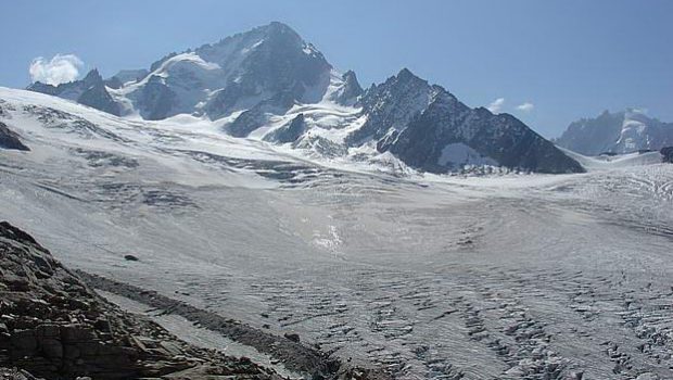
The situation of the shelter perched above the Glacier du Tour, in front of Aiguille du Chardonnet and Aiguille du Tour offers a unique panorama on the high mountain universe.
The sensation of altitude is intense in front of the crevasses of this imposing glacier that one follows throughout the ascent.
The eye is also attracted by Aiguilles Rouges on the other side, and Le Tour village that seems very tiny.
From the arrival of the chairlift of Balme, the road is well traced in the direction of the Albert 1er Refuge. The itinerary is easy: there is just a short exposed walkway with a metallic ramp. It makes this hike an accessible objective for a safe discovery of the high mountains.
As the track is flirting in places with steep slopes, a piece of rope to belay younger children is advised.
For the descent, a variant to the “normal” trail allows following the glacier along its length and offers a panorama that makes it more attractive.
Beware, this route, although shorter, remains much harder: the descent of the moraine into the rock debris is physical and the slope is in places very abrupt and can scare people having a fear of heights.
- Difficulty: Intermediate
- Altitude: 2,702 m
- Ascent: 1 hour 40 min
- Descent: 2 hours 30 min
- Elevation Gain: 550 metres from the arrival of the Autannes chairlift / 990 metres from the arrival of the Charamillon cable car
- Round-trip: 7.4 km from the arrival of the Autannes chairlift / 9.2 km from the arrival of the Charamillon cable car
- Map: IGN 3630 OT
Getting There
From Chamonix, take the direction Argentière by the N506 road. After the village, take the small road on the right in the direction of Le Tour, Montroc. Park in the large car park in front of the Charamillon cable car.
Prices and timetables of the Col de Balme ski lifts.
Fares and Timetables of the Col de Balme’s cable car and ski lift.
GPS Coordinates (WGS 84) of the Starting Point: 46.003168, 6.946500
Ascent
From the car park, take the Charamillon cable car and then the Autannes chairlift. Upon arrival, take the trail on the right that indicates the Albert 1er Refuge.
The path doesn’t go up much as it crosses south towards Mont Blanc until a small fork where a pathway goes to the left towards the Lac de Charamillon. Continue until you reach the road that goes up to the right from the arrival of the gondola of Charamillon: it is this footpath that will be used for the return journey by the usual way.
The footway is narrower at the end of the Picheu and discovers a magnificent view on the Glacier du Tour. The path gets into the stony ground and a quick passage equipped with a ramp allows crossing this slightly delicate part.
Upon arrival on the moraine, a sign intersects with the trail for the descent’s alternative route.
The ascent of this moraine in a straight line is the most trying part, the slope being abrupt.
Under the refuge, the pathway becomes steeper, and after short switchbacks, the platform of the former Albert 1er Refuge appears as well as the stone shelter that awaits you for a well-deserved break.
The smell of the grilled sausages on the barbecue opens the appetite.
Do not hesitate to continue the cairn path above the Albert 1er Refuge that leads to an overlook on the glacier, facing Aiguille du Tour.
Attention, the hike stops here! Do not venture on the glacier: this is another area that requires experience, material, and accompaniment of a guide.
Descent
Go down the same road to the sign located on the moraine and turn right on the trail. Proceed until you find the bifurcation and take on the left the pathway that leads to the arrival of the gondola of Charamillon.
From there, follow the steep track that goes to the parking lot.
Alternative route: On the moraine, at the signpost, continue straight leaving on the right the classic route and descend following the ridge in the rocky debris along the glacier.
The slope is steep and the terrain slippery. At the end of the moraine, at the height of the waterfall, one reaches the Fenêtre du Tour and a concrete building.
The rare vegetation until then is more present, and the path turns right to cross the brook of the Picheux.
Very steep and at times quite exposed, the trail quickly loses altitude. After walking through the forest, you arrive at a meadow with two ski lifts.
Proceed and get to the parking lot.
Photos of Albert 1er Refuge
Route
Download the route (KML) Download the route (GPX)


This post is also available in Français


