Lac Lioson And Pic Chaussy
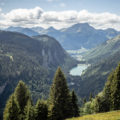
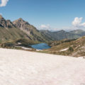
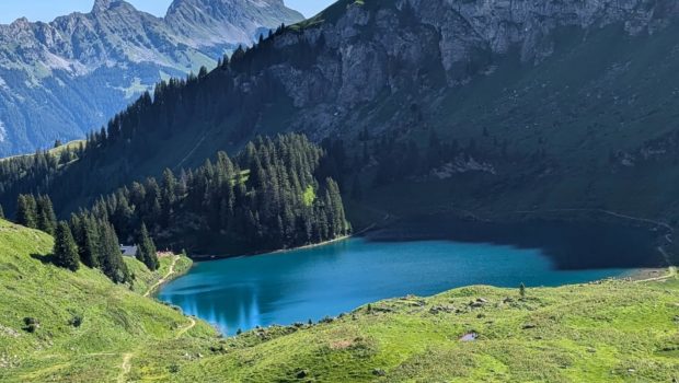
Lac Lioson and Pic Chaussy in the commune of Ormont-Dessous are two not-to-be-missed peaks in the Chablais region of Vaud. This is an out-and-back hike, the aim of which is first to reach a magnificent little lake nestling between the peaks of the Chablais vaudois. The second part will take you up to the Pic Chaussy, a veritable promontory offering 360° panoramic views of the Mont Blanc chain, the Diablerets massif and many other peaks (including the Moléson).
- Difficulty: Easy for Lac Lioson
Intermediate for Pic Chaussy
- Altitude: 1,848 m for Lac Lioson ; 2,351 m for Pic Chaussy
- Ascent: 0 hour 30 min for Lac Lioson ; 2 hours 00 min for Pic Chaussy from the car park
- Descent: 1 hour 30 min
- Elevation Gain: 770 meters
- Round-trip: 7.95 km
- Map: Carte nationale 1265 Les Mosses
Getting There
From Aigle, take the Col des Mosses road to Les Mosses village. Once you reach the centre of the village, leave the Col des Mosses road and turn right onto the Chemin du Lioson. Follow this path to the start car park. Please note that the ‘Lioson d’en bas’ car park can accommodate around 15 vehicles. If it is full, park just before the car park in the meadows below.
GPS Coordinates (WGS 84) of the Starting Point: 46.392171, 7.117767
Ascent
From the car park, take the path on the left that leads to the sign for ‘Lac Lioson’. Follow the track for about 30 minutes to reach the lake. Once you reach the restaurant, turn right and follow the sign to ‘Pic Chaussy’.
Continue along a well-marked path with red and white markings until you come to a sign for ‘Pic Chaussy’. The climb then becomes steeper and the summit is now clearly visible. Short hairpin bends take you up to the pass, symbolised by the ‘Pic de Chaussy’ sign. However, the summit is on the right and requires a final effort over a short, fairly steep climb.
The view from this observatory is spectacular, taking in all the surrounding peaks.
Descent
Take the same path to the lake, but follow it around to the right bank, then take the carriageway back to the car park.
Photos of Lac Lioson and Pic Chaussy
")
")
")
")
")
")
")
")
")
")
")
")
")
")
")
")
")
")
")
")
")
")
")
")
")
")
")
")
")
")
")
")
")
")
")
")
")
")
Route
Download the paper route (PDF) Download the route (KML) Download the route (GPX)
This post is also available in Français
About the Author
Pierre-Alexandre 32 ans, fondateur et webmaster de Randos-MontBlanc. Suivez-moi sur @pierrealexphotography