Rifugio Bertone, Testa Bernarda, and Tête de la Tronche
An itinerary of anthology, a permanent dazzling, a long day of contemplation facing the most beautiful summits of the Alps … this is what I propose through this hike for experienced walkers.
This itinerary, which describes a loop, is long with an important elevation, but without any technical difficulty.
The hike follows the route of the Tour du Mont Blanc and passes by the Rifugio Bertone, continues through Montagne de la Saxe, Testa Bernarda, Tête de la Tronche to finally descend down Col Sapin.
Back in the car park, in spite of fatigue, the magic moments in front of the immensity of this magnificent balcony facing Mont Blanc will be etched forever in the memory of the hiker.
Make sure to wait until the beginning of July so that all névé disappears, otherwise the descent through Col Sapin would prove to be very perilous.
- Difficulty: Hard
- Altitude: 1,991 m at the Rifugio Bertone, 2,534 m at Testa Bernarda, 2,584 m at Tête de la Tronche
- Ascent: 1 hour 30 min for the Rifugio Bertone + 1 hour 30 min to get to Testa Bernarda + 0 hour 15 min to get to Tête de la Tronche
- Descent: 2 hours 15 min from Tête de la Tronche (5 hours 30 min in total)
- Elevation Gain: 1,240 meters
- Round-trip: 12.3 km
- Map: IGC 107
Getting There
From Chamonix, take the Mont Blanc Tunnel to Courmayeur. Take the direction of “Centre-Ville” on the left, then the direction of Villair—Val Sapin.
Sneak through the little streets of Villair to the road terminus. Do not hesitate to continue after the “dead-end” sign: the road turns into a very widely accessible road for about 300 m until a small car park on the left in front of the information signpost on the TMB.
GPS Coordinates (WGS 84) of the Starting Point: 45.801185, 6.984683
Ascent
From the parking lot, take the stone road past the gate and cross the little bridge over the torrent. Shortly afterward, a marker “42 TMB” invites to follow on the right a trail that goes up cheerfully in the wood.
The path rises rapidly over Courmayeur. After one hour and a half of climbing, most often in the shade of the forest, appears the imposing mass of Mont Blanc after a switchback.
The refuge is no longer very far: pass it on the right following the TMB markings to reach a small plateau that overhangs the chalets.
A small dome with a drinking trough, an orientation table, and a TMB arrows, allow a well-deserved break before beginning the rough climb on the Saxe mountain towards Tête de la Tronche.
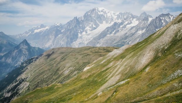
At the top, the well-marked path becomes practically flat. This balcony offers a continuous show, and many will find it difficult to detach the eyes from this fabulous scenery of snow and ice. Do not forget the binoculars in the backpack to observe the different refuges, seracs, and spikes that the most experienced can name or discover on a map.
Testa Bernarda approaches, and after an easy climb, the path passes very close to the summit materialized by a cairn; A slight detour can finally get to it.
After a short descent, take the non-dangerous ridge exposed to the heights in the direction of Tête de la Tronche reached quite rapidly.
This peak is the culmination of the itinerary. It offers a 360 ° panorama over the Val Ferret, the Mont Blanc Massif, Val d’Arminaz and Tête-Entre-Deux-Sauts, as well as Val Sapin and the Col de Liconi.
Descent
Take the steep pathway that descends to the Col Sapin reached in fifteen minutes. Follow the direction of “Villair by the Val Sapin.” Continue the well-marked trail that connects the short switchbacks and crosses a small stream before arriving at the Ruins of Curru. After crossing a new torrent, the flat track leads to a small plateau where a sign indicates the direction of the Col de Liconi that must be left on the left. A wooden portico (the site was a former site of skidding) overhangs the hamlet of Chapy, the next objective, leaving the footway that leads to Suche. The somewhat steep lace leads quickly to the settlement of Chapy.
Then go to La Trappe by a wider path which will arrive at the trail taken five hours and a half before, and reach the car park of Villair.
Photos of Rifugio Bertone, Testa Bernarda, and Tête de la Tronche
Route
Download the route (KML) Download the route (GPX)
This post is also available in Français


