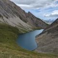
Lac du Fond
Lac du Fond is one of Valgrisenche’s hidden gems. It certainly has to be earned, but the effort involved is well worth it.
The path is quite steep and shady at first, but then reveals torrents and waterfalls at every bend. The route then continues over a large, gently sloping plateau, following a torrent as it tumbles down the valley in a series of waterfalls and cascades, before reaching the magnificent Lac du Fond.
- Difficulty: Hard
- Altitude: 2,480 m at lac du Fond / 2,650 at the viewpoint
- Ascent: 2 hours 45 min for lac du Fond + 20 min for the viewpoint
- Descent: 2 hours 00 min
- Elevation Gain: 810 meters for lac du Fond / 960 meters for the viewpoint
- Round-trip: 8.9 km
- Map: 03 — Carte des sentiers Valgrisenche
Getting There
From Courmayeur, take the SS26. Once in Arvier, take the SR25 towards Valgrisenche. After around ten kilometres, turn right towards Planaval. Go through the village of Planaval and follow the signs for La Clusaz. If you arrive very early, there are two parking spaces about 200 meters further on, in the second bend after the hamlet, where trail no. 21 starts. Otherwise, you need to park in the hamlet of La Clusaz, 200 m before.
GPS Coordinates (WGS 84) of the Starting Point: 45.676193, 7.090594
Ascent
From the La Clusaz car park, follow the road and, after a hairpin bend, turn left at the sign for “Lac du Fond – 2 h 25 min – 21A”. Continue along the partly shaded path, which rises quickly over short switchbacks. It passes several small waterfalls and a footbridge spanning a stream.
Once you reach the remains of a winch, continue on past the remains of a stone hut. The path becomes a little steeper before reaching the ruins of “A Bénévu – 1950 m”. Soon you’ll reach a water catchment where you can refresh yourself. The torrent is now very present until you reach a gentle plateau where you can admire the sublime scenery as you walk alongside the easily accessible torrent. Further on, a large rock indicates the road to follow towards the Col de la Crosatie.
Continue on to cross a small bridge over the torrent to the Baraques du Fond (2338m). At the cairn, follow the signs for “Lac du Fond”: the 30-minute indication is wrong – 20 minutes will be more than enough to reach the lake.
I recommend continuing along the path towards the Col de Crosatie to a small knoll so that you can observe the lake from this promontory. The view from here is magical.
Descent
Follow the same route as described above.
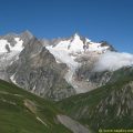
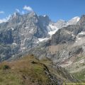
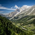
Photos of Lac du Fond
")
")
")
")
")
")
")
")
")
")
")
")
")
")
")
")
")
")
")
")
")
")
")
")
")
")
")
")
")
")
")
")
")
")
")
")
")
")
")
")
")
")
")
")
")
")
")
")
Route
Download the route (KML) Download the route (GPX)
This post is also available in Français
About the Author
Pierre-Alexandre 33 ans, fondateur et webmaster de Randos-MontBlanc. Suivez-moi sur @pierrealexphotography