Choranche Cave
A hike to the Choranche cave is a must for nature lovers and lovers of spectacular scenery. Located in the heart of the Vercors Regional Nature Park, this excursion takes you through breathtaking panoramas and well-marked paths, accessible to hikers of all abilities.
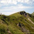
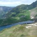
You start from the picturesque village of Choranche. Right from the start, the path plunges you into a green environment, typical of the region, with impressive limestone cliffs towering above the hiker. The climb is gradual, allowing you to take full advantage of the views over the Bourne valley and the surrounding mountains.
The Choranche cave is a real natural gem. Before entering the cave, take time to admire the view from the entrance: an expanse of dense forest with the peaks of the Vercors in the background. The cave itself is famous for its fine stalactites and emerald-green underground rivers. A guided tour of the cave is a must. You’ll marvel at the unique geological formations and the mysterious atmosphere.
It’s a rewarding and accessible hike, perfect for a day out with family or friends, combining nature, adventure and discovery.
- Difficulty: Easy
- Altitude: 593 m
- Total Time: 2 hours 40 min (without the visit of the cave)
- Elevation Gain: 600 meters
- Round-trip: 6.30 km
- Map: IGN 3236 OT
Getting There
Take the D531 to Choranche. The route starts from the car park a hundred metres before the cemetery.
GPS Coordinates (WGS 84) of the Starting Point: 45.066736, 5.389735
Ascent
From the car park, head towards the first signpost pointing to “Site de Choranche (grotte) – 1 h”. The path then begins at the edge of the woods on a well-maintained track with a moderate, even gradient. There are green and yellow markings along the way. Go straight on at the second signpost to “Site de Choranche”. At the next crossroads, turn right at the signpost and follow the signs for “Site de Choranche – 50 min”. You will then be on a tarmac track with a fairly gentle climb.
At the next signpost near the houses, which say “Presles” and “Porche de Coufin”, continue straight on towards the houses. The track then branches off to the left and rises until it intersects with a sign for “Ranconniere”. At the latter, follow the path on the right, again signposted “Site de Choranche – 35 min”. After a few minutes’ walk, you come to a small waterfall and a river that you have to cross using a small wooden footbridge.
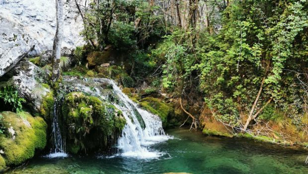
After this crossing, the slope becomes steeper on a gravel path. The presence of a few wooden steps on a small section of the path makes the climb easier. Further on, you come to the “Carrefour des Buis” sign on the left-hand path leading to the “Ruisseau de Gournier, Lac souterrain” (Gournier stream, underground lake). This little diversions gives you the chance to visit an underground lake, a remarkable site discovered over a century ago.
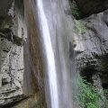
At the “Ruisseau de Gournier” sign, follow the path up towards the “Lac souterrain”, around 100 metres away. On the way there is a charming waterfall on the right and, finally, the magnificent and unusual underground lake. Follow the path back to the signpost you came across earlier indicating “Ruisseau de Gournier” to reach the original destination of the Grottes de Choranche. At this point, turn left over the wooden bridge towards the “Belvédère de la Cascade – 5 min”. After about 200 m on a fairly level path, you reach a promontory with an unobstructed view of the waterfall.
Continue along the path for a few hundred metres to reach the “Porche de Coufin” sign, which also indicates the entrance to the Grottes de Choranche site.
Descent
Then head for the car park at the Grottes site. Follow the tarmac road for about two kilometres. You’ll need to walk along the right-hand side of the road, as cars pass frequently, especially during the summer months. At the end of the 2 km, a signpost on the right-hand side of the road points the way to “Choranche – 35 min”. Take a small path that branches off to the right into the meadow.
The slope is quite steep on a soil and gravel surface that can roll underfoot; there is nothing dangerous here, just take your time. Continue along the path on an undiminished slope, passing through meadows and back into the undergrowth. The path then comes to a crossroads with a clear view: continue on the path opposite, where you will find a wooden post with a small white sign with no indication, which will take you back into the undergrowth.
The slope is then less steep and easier to descend, before leading to the main road. Cross the road to reach the signpost opposite and follow the signs for “Choranche – 5 min” with red and white GR markings on the trees. After a few minutes’ walk, you finally reach a public beach along the river “La Bourne”.
Continue on to the car port at the entrance to the beach, where you’ll see the sign indicating that you’ve arrived at “Choranche”. From here, turn right into the rising road and, at the junction, turn right over the bridge (signposted Pont-en-Royans). Follow the road for a few hundred metres, then turn right onto the lane where you will find parking spaces and a recycling area.
Continue straight ahead to reach the start car park.
Photos of Choranche Cave
")
")
")
")
")
")
")
")
")
")
")
")
 (7 août 2024)")
")
 (7 août 2024)")
")
")
")
")
")
")
")
")
")
")
")
")
")
")
")
Route
Download the route (KML) Download the route (GPX)
This post is also available in Français
About the Author
Pierre-Alexandre 32 ans, fondateur et webmaster de Randos-MontBlanc. Suivez-moi sur @pierrealexphotography